|
OS Grid Reference TR 199382.
On the escarpment of Cheriton Hill, overlooking
the Eurotunnel terminal, near Folkestone in Kent. The site is
privately owned, is very steep, is a candidate Special Area
for Conservation (SAC) and a Site of Special Scientific Interest
(SSSI), so access is restricted to the public footpath which
runs along the top of the hillside (from which a view of the
Horse is extremely limited and distorted).
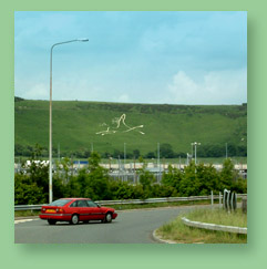
The hill figure needs to be seen from a distance. Fine views
are from Weymouth Road (off Cheriton High Street - TR 198370);
or the car park of the Tesco Superstore near the roundabout
over the M20 motorway at Junction 12 (TR 194370).
Statistics
Length (fore hoof to hind hoof) - approx. 93
metres / 306 feet
Height (nose to lower hooves) - approx. 48 metres / 160 feet
Number of slabs used, and number of stainless steel anchor screws
- approx. 700
Average width of outline - 60cm / 2 feet
Area of ground covered by slabs - approx. 250 sq. metres / 2800
sq.ft.
|